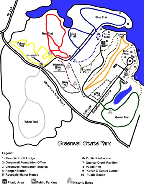
Blue Trail (Difficulty Level: Easy)
Passage to the blue trail (1.75 miles) requires use of the Gray Access Trail. The Gray Access
is approximately .45 miles through the soy fields. From the Gray Access Trail, the Blue Trail
turns right and travels into an open crop field. A grassy path loops around the edge of the
field with forest on one side. Through the trees, you may view the Patuxent River. While on
the trail, you may see wildlife such as ground hogs, song birds, and white tailed deer. Horses,
mountain bikes, and hikers are welcome. Back to Top of Map
Red Trail (Difficulty Level: Moderate)
From the Gray Access Trail (.45 miles), turn to the left for the Red Trail which stretches .73
miles. It travels mainly through deciduous forest. Keep an eye out for a family of gray squirrels
hopping through White Oak and Red Maple trees. This trail is suitable for hikers, mountain bikers,
and horses. Back to Top of Map
Yellow Trail (Difficulty Level: Easy)
The Yellow Trail (1.15 miles) is accessed by following the Gray Access Trail (.45 miles) and part
of the Red Trail. It veers to the left of the Red Trail. While traveling the trail, a grassy field
is to your left. This field is home to mice, moles, ground hogs and rabbits. On your right, an
inviting forest is filled with raccoons, owls and American Holly trees. Hikers, horses and mountain
bikers are permitted. Back to Top of Map
White Trail (Difficulty Level: Moderate)
The White Trail requires passage along the Gray Access Trail (.45 miles), and across Steer Horn
Neck Road. This trail is predominantly a hardwood forest. You will find a variety of vegetation
such as American Beech, Red Oak, Spice Bush, Mountain Laurel, and many types of grasses. At one
point, Cuckold Creek can be viewed from the trail. Hikers, horses and mountain bikers are welcome.
Back to Top of Map
Green Trail (Difficulty Level: Easy (not in hunting area))
This trail may be accessed either by Rosedale Manor Road or the River Trail. It winds through
crop fields and woods. There are many side spurs allowing the visitor to overlook a tidal pond
that hosts a great variety of wildlife and birds. Back to Top of Map
Historic Barn Trail (Difficulty Level: Easy)
.15 mile path past two historic tobacco barns (one of which is the oldest barn in St. Mary's County).
Back to Top of Map
|